
Gritty inner city areas and wealthy suburbs feature more evenly among the churches in this week’s analysis – in contrast to the focus on the Salvation Army and RCCG in my previous blog.
The FIEC and Gospel Partnerships have a combined membership of more than 900 churches and have much in common in their doctrine – in fact, some churches are members of both organisations. So it is unsurprising that their churches can be found in similar areas.
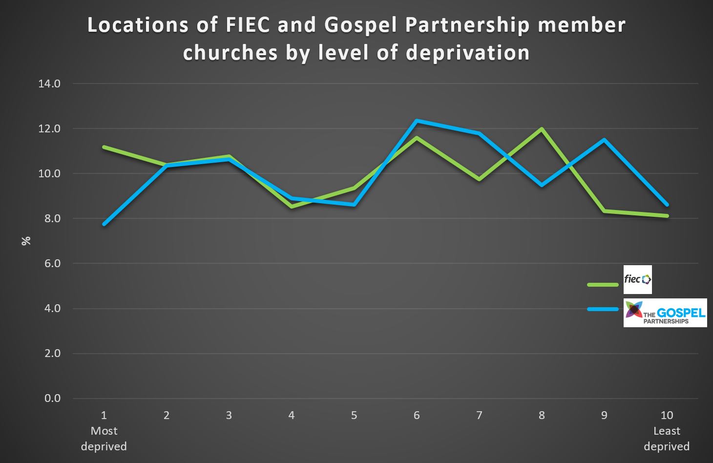
However, there are some differences. Overall, about half (50.2%) of FIEC churches are located in the poorer half of the country, while slightly fewer (46.3%) Gospel Partnership churches can be found in these areas. And if you live in an area within the most deprived 10% of the country, it’ll be harder for you to find a congregation linked to the Gospel Partnership as this is where they have the fewest churches (7.8%).
A difference in regional location
Perhaps the clearest trend among the Gospel Partnerships network is its strength in the South East and London, where it has more churches than it does in the rest of England put together. 54.9% of the network’s churches are located in the region that’s home to 32% of the country’s population.
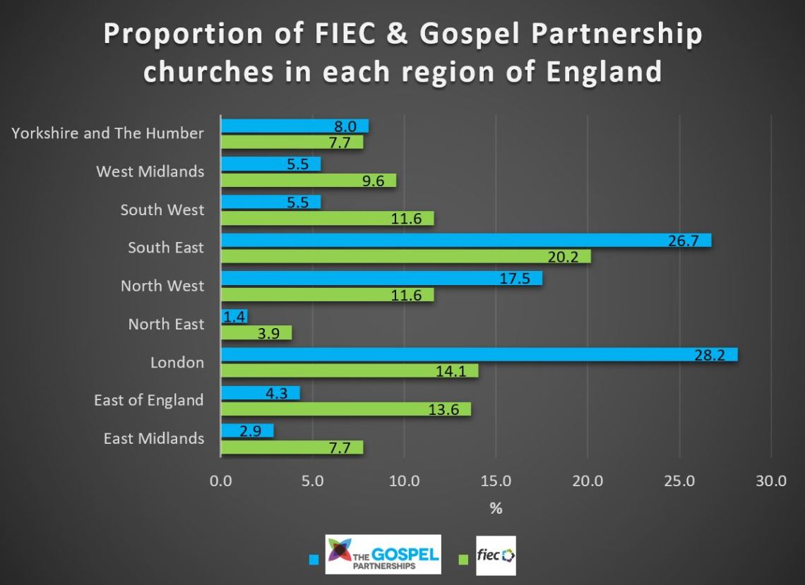
FIEC is more evenly spread across the country, though the organisation also has a slightly higher proportion of its member churches in the South East with one in five (20.2%) located in the region home to 16.3% of England’s residents.
The population of these regions does indicate that more churches are needed in comparison to other regions, though analysis shows the rate of churches per people is higher too.
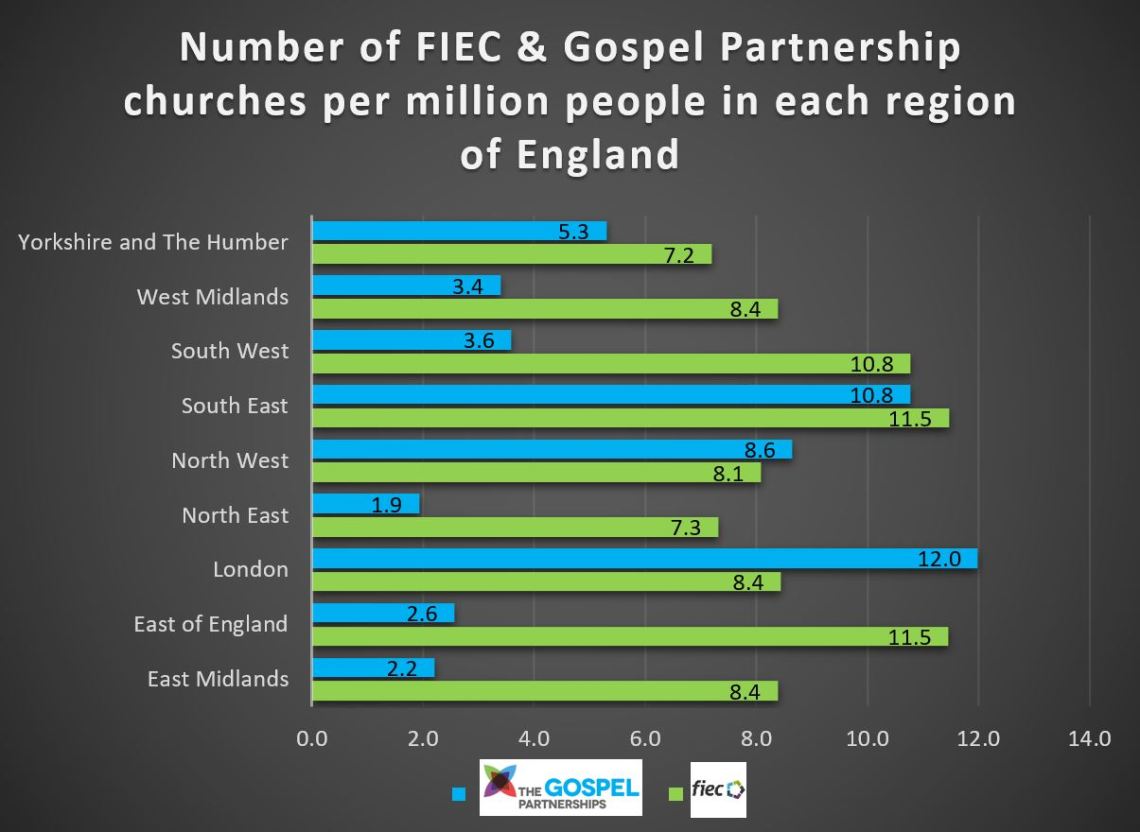
A great opportunity therefore exists for churches that belong to the FIEC and Gospel Partnership networks to consider church planting in areas such as the North East, where their presence is most limited.
You can explore the locations of churches in England belonging to the networks in the following map. For more precise locations and information, please visit the FIEC or Gospel Partnership websites.
Sources:
http://imd-by-postcode.opendatacommunities.org/
https://www.doogal.co.uk/BatchGeocoding.php
The information in the charts is based on available postcode locations of churches in England as published on the respective network websites and their respective Decile positions (ranking 1-10, where 1 is most deprived) in the Indices of Multiple Deprivation, and region according to the NUTS 1 statistical regions of England.

Reblogged this on Windy London and commented:
More useful data from Tom
LikeLike
Very helpful indeed.
One slight issue I’ve found is that it is difficult to distinguish between “network” churches and “local” churches. Some RCCG and Gospel Partnership churches will be based in poorer postcodes because that is where accomodation is cheap, but the congregation is middle class and mobile. This is less the case for Salvation Army & FIEC who tend to have a more local focus.
Would love to chat more about this work…
LikeLike
Thanks so much for your interest, Graham. It’s very encouraging. I will DM you. Cheers T
LikeLike
Would be interested to see you include Wales in this…
LikeLike
Wales is a bit trickier to get deprivation data per location, but I can have a go. Also, from memory there are very few (if any) Gospel Partnership churches, so it would be FIEC only. Thanks for the comment.
LikeLike